Digital Twins for Cities
| Language: | German |
| Location: | Munich, Online |
| Duration: | 6 days in 2 weeks |
| Start: | TBA |
| Cost: | 3,750 EUR |
| ECTS: | 3 |

A great advantage is the simple and clearly understandable visualisation of complex calculation results in the models. In this way, they provide reliable support for citizen participation and decisions on improving mobility flows, meeting climate targets, developing new construction areas or implementing security concepts.
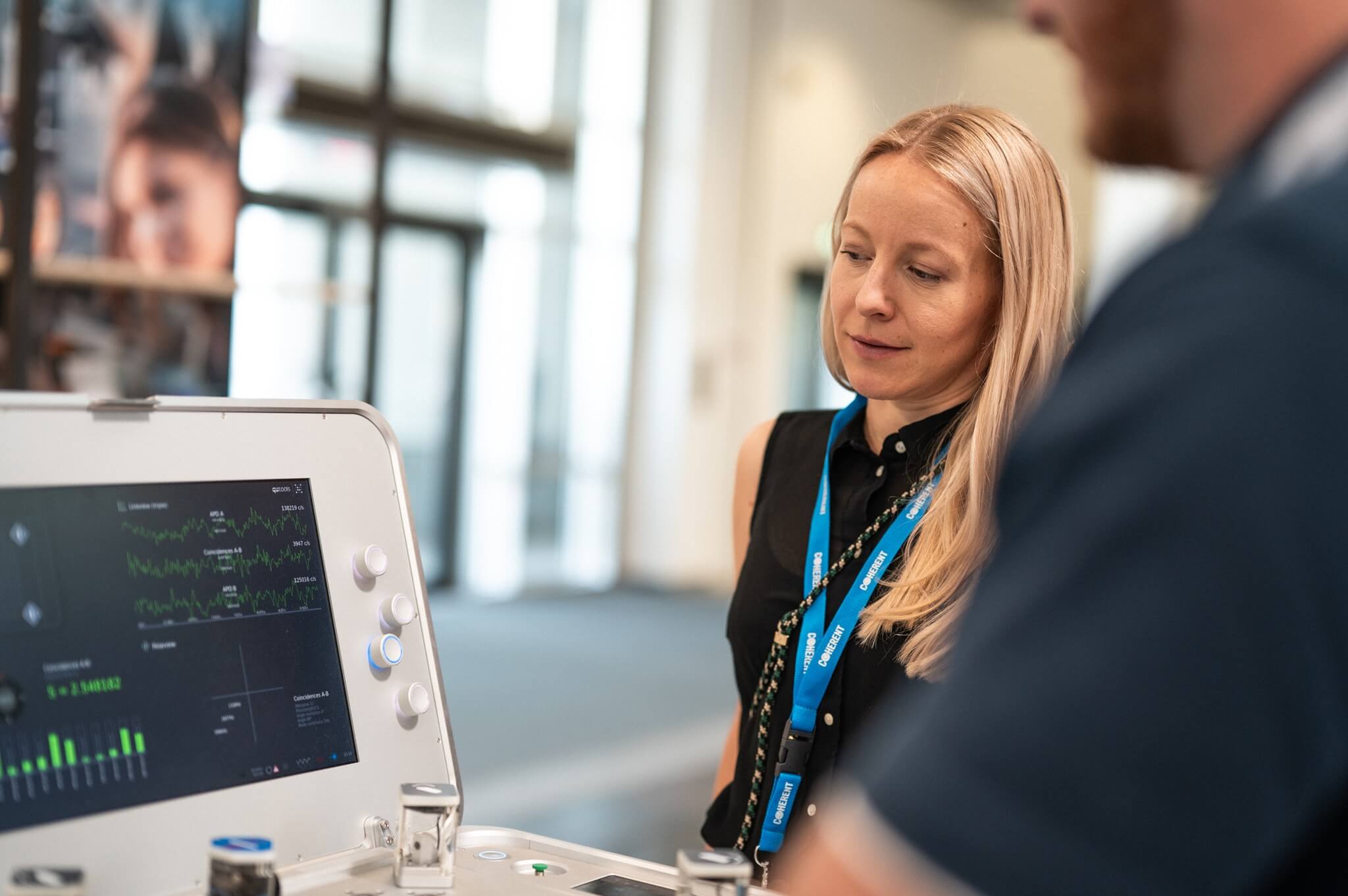
The group of participants is limited to a maximum of 20 people and is made up of executives and project managers from the fields of urban planning, engineering and architecture offices, municipalities, surveying and geodesy as well as business development Smart City.
Within our certificate course we discuss questions such as:
 What are Digital Twins for Cities?What standards are there?What data are included?How can the Digital Twins for Cities be used?What are the components of Digital Twins for Cities?
This certificate program can be credited with 8 DGNB continuing education points for licensed DGNB certification experts (DGNB Consultants, DGNB Auditors, DGNB Senior Auditors).
Benefits
01
1
Innovative Urban Modeling
02
2
Practical Expertise
03
3
Exclusive Network
Program Overview
Here you will find information on the aims of this course and its content.We present innovative methods from the fields of civil engineering, geoinformation and urban planning. Evaluate the possibilities of digital networking and emerging new business models. Get to know cross-topic and cross-scale digital analysis methods. Develop individual solution strategies for complex urban issues. Build up your network for future activities.
Here you will find information on dates, requirements and other general conditions for the certificate program.Program:
Digital City – Modeling, Analyzing & Deciding
Target group:
Executives and project managers working in town planning and architecture
Employees responsible for planning at communal institutions
Experts within the fields of Smart City, measurement and geoinformation
DGNB certification experts
Academic responsibility:
Prof. Dr. rer. nat. Thomas H. Kolbe
Prof. Dr.-Ing. Frank Petzold
Prof. Dr.-Ing. André Borrmann
Format & Timing:
2 modules in 2 weeks
Study location:
Online and on Campus (Munich)
Language:
German
Dates:
TBA
Application deadline:
TBA
Admission requirements:
Participants should have relevant work experience of at least 2 years and ideally a higher education degree or a degree from a university of applied sciences.
Graduation:
After successfully passing the final examination, you will receive a certificate from the Technical University of Munich.
ECTS:
3 ECTS
Creditability:
This certificate program can be credited with 8 DGNB continuing education points for licensed DGNB certification experts (DGNB Consultants, DGNB Auditors, DGNB Senior Auditors).
Program fee:
3,750 EUR*
Discounts:
10% discount for TUM Alumni and members or employees of our strategic cooperation partners (see below).
Get to know our experienced lecturers who will teach you the certificate content and with whom you will work.Prof. Dr. rer. nat. Thomas H. Kolbe,
Chair of Geoinformatics, TUM
Corné Helmons,
Expert for GeoBIM and Digital Twins, Representative of the Rotterdam City Administration
Prof. Dr. André Borrmann,
Chair of Computational Modeling and Simulation, TUM
Prof. Dr.-Ing. Frank Petzold,
Chair of Architectural Informatics, TUM
Prof. Dr. Ludwig Hoegner,
Professor of Geodesy, Munich University of Applied Sciences
Dr.-Ing. Hannes Harter,
Co-Founder and Managing Partner, Vesta Sustainability Consulting
Dr. Stefan Trometer,
Managing Director Business Development, Virtual City Systems
Dipl.-Ing. Markus Hochmuth,
Managing Director / CEO, OBERMEYER Digital Solution GmbH
Korbinian Kringer,
Strategist for Spatial Data, GeodataService Munich
Dr. Robert Roschlaub,
State Office for Digitalization, Broadband and Surveying
Prof. Dr. Silja Hoffmann,
Professorship for Intelligent, Multimodal Transport Systems, University of the Bundeswehr Munich
Dr. Gerhard Schubert,
Chair of Architectural Informatics, TUM
Nils Seifert,
Urbanist
Find out here how the course is structured and what the individual modules of the certificate program contain.Digital city modeling
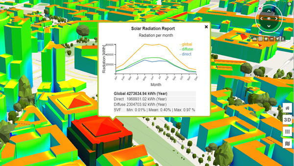
Modern solar potential analyses allow the evaluation of façade surfaces and the consideration of shading effects from buildings, vegetation and terrain. With the solution developed jointly by TUM and Virtual City Systems GmbH, you can balance the potential on a monthly basis and have it displayed and evaluated for each individual building.
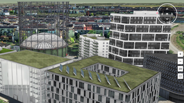
Digital planning and construction (BIM)
We will show you how the new worlds of Building Information Modeling (IFC) and Urban Information Modeling (CityGML) are growing together using the visualization of BIM models in the context of the semantic 3D city model of Berlin by Virtual City Systems GmbH.
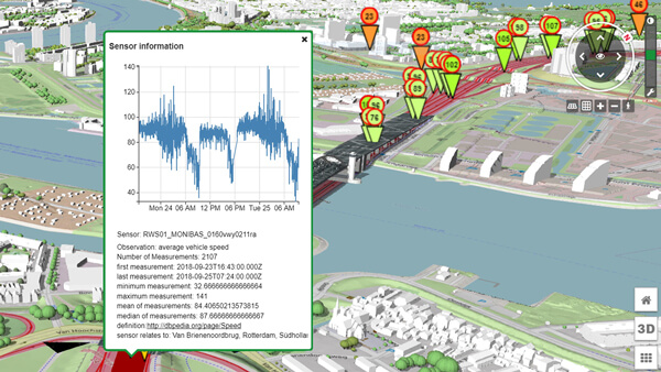
Application (mobility, environment and housing)
Web-based 3D city models, as shown here using the example of Rotterdam, can be expanded into data hubs and can be linked with real-time sensor systems for traffic events.
Testimonials
-

The TUM Institute for LifeLong Learning’s “Digital Twins for Cities” course was a highlight of 2023. The hybrid approach allows for effective knowledge transfer and valuable networking in equal measure. The quality of the speakers and participants was excellent. I was able to take a lot of knowledge and inspiration with me into my everyday professional life. The only open question is which course I will attend at TUM LLL 2024.
Peter Rummel
Partners


Info Sessions
Request form for certificate programs Executive & Professional Education
"*" indicates required fields
-
Your contact
Dr. Lisa WintersbergPhone: +49 152 03429626